Asset A · Direct, off-market sale
9,236 sq m of land in north Bucharest, by the Ring Road
City of Bucharest, Sector 1 · on the Otopeni border
- measured area, buildable land
- 9,236sq m
- with asphalt access, HGV access
- 2sides
- water, sewer, gas, 3-phase power, fibre
- 5networks
- Bucharest Municipality, Sector 1
- S1
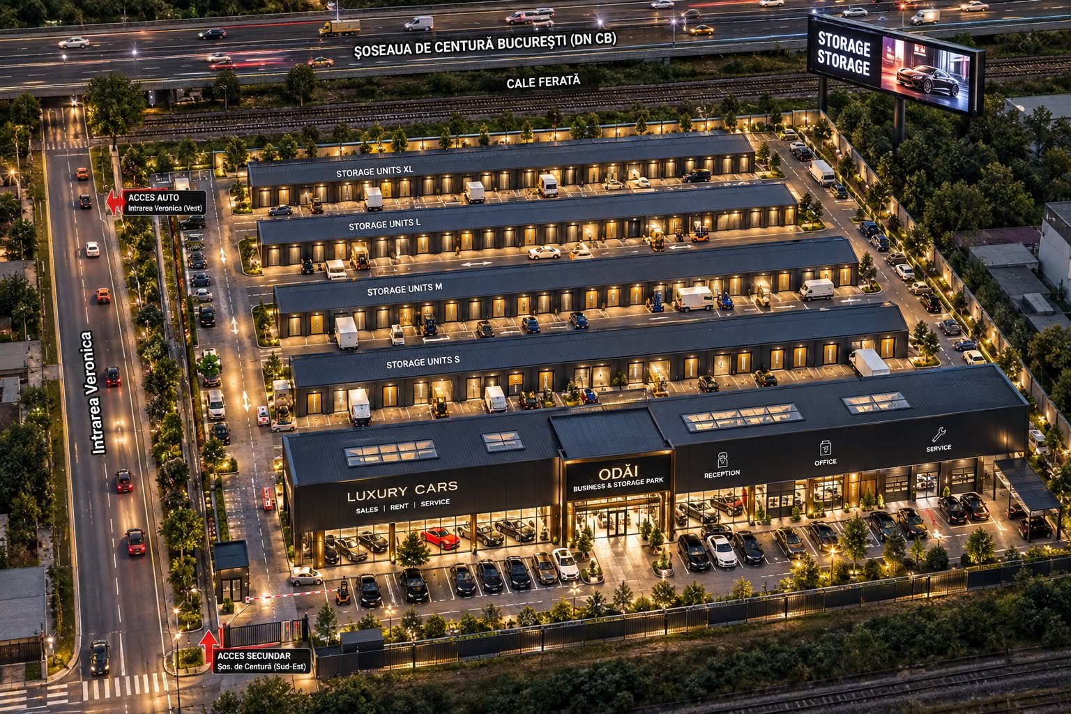
Illustrative concept: business and storage park. A development scenario, subject to a new zoning plan.
Investment case
Why this asset
Close to one hectare of vacant, fenced urban land inside the administrative limits of the capital. Utilities are in the area and paved road access runs along two sides.
- Rare size within the City of Bucharest: close to one hectare in a single plot, in Sector 1 rather than Ilfov County.
- Transit location: the Bucharest Ring Road and DN1 next to the site, Henri Coandă International Airport nearby.
- Ready for design: vacant land with nothing to demolish, and water, sewage, gas, three-phase power and fibre networks in the area.
- Value created through zoning: a new zoning plan (PUZ) unlocks development, on indicative parameters of 50% site coverage and FAR 1.8.
Asset sheet
Key data
| Plot area | 9,236 sq m measured9,237 sq m per title · land-book extract |
|---|---|
| Sides | 137.5 · 78.1 · 121.0 · 65.0 msite and boundary plan, March 2025 |
| Land category | yards and buildings, within the built-up areatax zone B |
| Administrative unit | City of Bucharest, Sector 1 |
| Access | paved road on two sides; HGV access |
| Utilities | water, sewage, gas, three-phase power, fibreavailable in the area |
| Railway | CFR line runs alongside the plotno siding |
| Geotechnical study | availablein the data room |
| Condition | vacant, fenced |
| Encumbrances | free of encumbrancesper the owner's declaration; updated land-book extract in the data room |
| Owner | Romanian company, 100% ownershipidentity disclosed under NDA |
Zoning
Zoning: where the value lies
The plot was covered by an approved zoning plan for residential use, with a basement + ground + 5 floors + attic height regime, 40% site coverage and FAR 2.1. That plan has expired.
Under the General Urban Plan the site lies in sub-zone S1 with unregulated status. The Sector 1 City Hall indicates recommended values of 50% site coverage and FAR 1.8, and requires a new zoning plan for plots over 3,000 sq m.
For a developer experienced in permitting, this step is the main source of value: at FAR 1.8 the indicative capacity is approximately 16,625 sq m of gross floor area.
The parameters are indicative, as stated in the informative urbanism certificate, and do not constitute a building right. Final uses and height are set through the zoning plan.
Indicative calculation
Capacity estimator
An illustrative calculation on the indicative parameters in the urbanism certificate. Adjust the ratio and the size of one unit.
Illustrative calculation on indicative parameters (POT 50%, CUT up to 1.8), subject to a new zoning plan. It is not a building right; final uses and height are set through the zoning plan.
- Footprint at POT 50%
- 4.618 sq m
- Gross floor area
- 16.625 sq m
- Units (estimate)
- ≈ 255
- Price per sq m of GFA
- ≈ 60 € · 50 € (fără TVA)
Use scenarios
Use cases and business ideas
Indicative scenarios for what can be done with this asset. They are not commitments and do not replace permit checks; each shows what supports the idea and what is still required.
Residential and mixed-useAfter rezoning
Homes with ground-floor retail, close to the Ring Road and DN1.
- Why it fits
- At indicative parameters (CUT 1.8), approx. 16,625 sq m of gross floor area on a single 9,236 sq m plot.
- What is still required
- New zoning plan; residential use is confirmed through the plan.
Value through zoningAfter rezoning
The investor takes the zoning plan through and then develops or resells the land with clarified rights.
- Why it fits
- Vacant land, no demolition; a previous residential zoning plan, expired.
- What is still required
- Feasibility, timing and cost of a new plan, to be set with a planner.
Business park and officesAfter rezoning
Office buildings and flexible space for small firms, with parking.
- Why it fits
- A single plot, utilities in the area, paved access on two sides.
- What is still required
- New zoning plan.
Last-mile logistics and cross-dockAfter rezoning
Urban storage at the entrance to Bucharest, with deliveries into the city.
- Why it fits
- HGV access, Ring Road and DN1 nearby, fenced land.
- What is still required
- New zoning plan; use is confirmed through the plan.
Self-storage and urban storageAfter rezoning
Units and storage space for individuals and businesses.
- Why it fits
- Vacant land, with paved road access and utilities in the area.
- What is still required
- New zoning plan.
Showroom and car serviceAfter rezoning
A dealership or service centre with road exposure and delivery access.
- Why it fits
- Paved access on two sides, including for HGVs.
- What is still required
- New zoning plan.
Airport parking and transit servicesAfter rezoning
Long-stay parking, a transit hotel or traveller services.
- Why it fits
- Henri Coandă Airport nearby (distance to be confirmed in the memorandum).
- What is still required
- New zoning plan; distance and use to be confirmed.
Land bankingPossible now
Urban land held for later development, with no immediate investment.
- Why it fits
- Almost one hectare in a single lot, in Bucharest.
- What is still required
- Tracking of the zoning plan and infrastructure plans.
Illustrative scenarios, subject to permits, rezoning and the investor's own verification.
Current photographs and aerial footage of the site: on request and during the site visit.
Transaction
Deal structure
Asset sale. Following review, the transaction can also be structured as a transfer of shares in the owning company, with appropriate due diligence.
Tax and legal aspects are confirmed with each party's own advisers.
FAQ
Frequently asked questions
What can be built on the land?
A zoning plan approved for residential use (S+P+5E+M, POT 40%, CUT 2.1) previously applied; it has expired. Plots above 3,000 sq m need a new zoning plan. The Sector 1 City Hall indicates indicative values of POT 50% and CUT 1.8. These are not a building right; final uses and height are set through the zoning plan.
Is the land vacant, and are utilities available?
Yes, the land is vacant and fenced. Water, sewage, gas, three-phase power and fibre are available in the area, and access is by paved road along two sides, including for HGVs.
Can the owning company be acquired instead?
Following review, the transaction can also be structured as a transfer of shares in the owning company, with appropriate due diligence. Tax and legal aspects are confirmed with each party's own advisers.
How do I receive the documents?
After the confidentiality agreement is signed you receive the information memorandum and data room access, with the asset's legal, cadastral and technical documents.
Asset A
Request the memorandum
The information memorandum covers the legal, cadastral and technical documents of the asset. It is shared after the confidentiality agreement is signed.